
Toyota Motor Corporation has announced the launch, in Japan, of its TC Smartphone Navigation app which will include aerial photographs of disaster areas in the route history map display in the case of large-scale disasters such as the earthquakes and tsunamis which regularly strike the country.
Toyota has been providing T-Probe traffic information – proprietary traffic congestion information based on big data collected from vehicles equipped with on-board data communication modules (DCM) – on the paid T-Connect smartphone app which suggests routes to avoid traffic congestion (at a cost of JPY2,500/US$22 a year).
Go deeper with GlobalData
Discover B2B Marketing That Performs
Combine business intelligence and editorial excellence to reach engaged professionals across 36 leading media platforms.
At the same time, the route history map, which helps to support relief activities in the event of a disaster, has been made available on Toyota’s website free of charge. This feature is also based on information collected from big data, and displays the vehicle’s route history. The route history map is also compatible with smartphones.
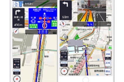
Toyota said the app would “further improve visibility and operability of the existing navigation function”.
It also displays T-Probe traffic information and route history map throughout the driving journey.
“In order to provide safe and convenient mobility support services to a wide range of customers, this service will be offered free of charge,” the automaker said. “The aim is to accumulate customer experience with the daily utilisation of [this] information where data utilisation in the event of a disaster has been enhanced.”
Aerial photographs of disaster areas will be made available in the route history map display in the case of large-scale disasters. Next summer, a navigation route search function which will incorporate the route history map will be added to further strengthen disaster countermeasures.
TC Smartphone Navigation will openly link with various external service providers in future. As a first step, Toyota will promote linking with services provided by akippa, a parking lot sharing service provider to offer search and reservation services, as well as navigation service to a reserved parking lot. A ink to services developed by Park24 is also planned.