
Ford announced at the 2016 CES show in Las Vegas today a plan to encourage development of drone-to-vehicle communications using its SYNC AppLink or OpenXC platforms. The goal: a surveying system for the United Nations Development Programme to inspect emergency zones inaccessible to even the most versatile vehicles.
Working with DJI, said to be the world leader in professional-grade drone systems and software, the automaker has invited innovators to participate in the DJI Developer Challenge to create technology which could allow UN first responders to earthquakes or tsunamis to quickly deploy drones able to survey and map hardest-hit areas – from the cab of a truck.
Go deeper with GlobalData

Discover B2B Marketing That Performs
Combine business intelligence and editorial excellence to reach engaged professionals across 36 leading media platforms.
Ken Washington, Ford’s head of research and advanced engineering, said: “There is an opportunity to make a big difference with vehicles and drones working together for a common good.”
The challenge winner receives US$100,000.
The challenge is part of Ford’s Smart Mobility, the automaker’s planned next step in connectivity, mobility, autonomous vehicles, customer experience, and data and analytics.
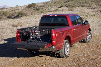
F-150 as drone base station
Developers are tasked with creating software that would allow an F-150 pickup truck and a drone to communicate in real time. The UN’s rapidly deployable surveying system ideally would work like this:
- In a disaster, an emergency response team would drive the truck as far as possible into an emergency zone caused by an earthquake or tsunami
- Using the SYNC touch screen, the driver could identify a target area and launch a drone by accessing an app projected through AppLink
- The drone would follow a flight path over the zone, capturing video and creating a map of survivors with associated close-up pictures of each
- Using the driver’s smartphone, the truck would establish a real-time link between the drone, the truck and the cloud, so vehicle data can be shared. Data will be relayed to the drone so the driver can continue to a new destination, and the drone will catch up and dock with the truck
- Developers will be able to use vehicle data available through SYNC AppLink or the OpenXC platform to create seamless drone-to-vehicle communications
Though this challenge has a specific goal, Ford said the software eventually could allow drone-to-vehicle applications in agriculture, forestry, construction, bridge inspection, search and rescue, and many other work environments in which vehicles are space-, height- or terrain-limited.